March 14, 2024
How satellites and AI ignite hope in Canada's battle against wildfires
BY DR. NADINA GALLE
In 2023, Canada faced a wildfire season that seared itself into the nation's history books — a relentless onslaught of over 6,500 fires consuming nearly 19 million hectares, and causing unprecedented destruction.
As Canada grapples with the aftermath, the conversation around innovative solutions takes centre stage. A dedicated effort is now underway to unravel the intricate causes of wildfires and institute preventative measures. But wildfires are inherently complex, requiring a comprehensive approach. This involves reflecting on current forestry practices, development in fire-prone areas, and, as I will discuss with you today, the integration of state-of-the-art technologies.
While wildfires are a natural part of our landscape, our landscapes are no longer natural. Long-term mismanagement of forests, compounded by anti-logging policies on federal and provincial lands, has resulted in the accumulation of dead and dying trees. This abundance of flammable material not only acts as dangerous fuel for wildfires but also hampers the forests' capacity to sequester carbon. The consequence is a dangerous cycle where dead trees become fuel for megafires, releasing carbon emissions that impact regional and global climates, contributing to a chain reaction of climate change-related events and further wildfires.
Addressing catastrophic wildfires demands a multifaceted solution, requiring a fundamental shift in perspective towards coexisting with fire, implementing healthy forest management practices and reducing triggers for wildfires. Natural Resources Canada reports that approximately half of wildfires result from lightning strikes, which is challenging to control except through the reduction of fuel loads. However, the remaining half, largely attributable to human activities such as conflicts arising between vegetation and power lines, presents a tangible opportunity for intervention.
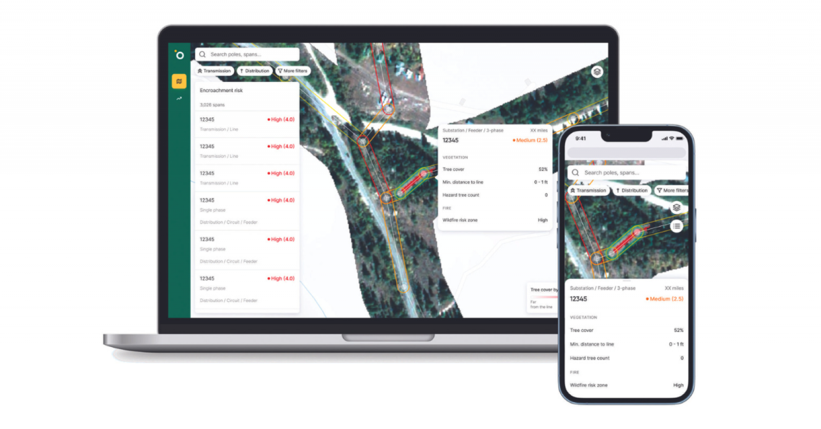
This prospect forms the heart of Amsterdam-based Overstory's mission. Leveraging satellite technology and artificial intelligence, Overstory focuses on vegetation management, particularly in proximity to power lines. This approach holds critical significance in safeguarding utility infrastructure, as overgrown vegetation poses not only a threat to power systems but also a substantial risk of wildfires. Electric cooperatives, utilities and landscape professionals can gain proactive planning capabilities by employing a comprehensive inspection plan.
Historically, landscape managers have adhered to a time-based trim cycle, whether every five or 10 years. Most utility companies have “line walkers,” people who walk along the power lines or get reports from crews working on the lines if they notice anything wrong. But checking the lines thoroughly by walking them regularly can take a long time, usually between 18 months to two years. Plus, because we're all human, mistakes can happen and the crews might miss some potential risks during these checks.
It was an approach that was effective enough until more frequent and intense droughts and heat waves heightened wildfire risks. The need for a risk-based strategy, integrating vegetation intelligence, became evident in the experiences of utility companies like Holy Cross Energy in Colorado and Sho-Me Power Electric Cooperative in Missouri.
Holy Cross Energy's goal to transition to a risk-based program by 2025 underscores the importance of real-time insights, especially in regions grappling with severe droughts. Similarly, Sho-Me Power Electric Cooperative's adoption of vegetation intelligence in 2021 eliminated the need for traditional aerial surveys, resulting in targeted vegetation removal without additional budgetary strain. While it’s impossible to quantify how many wildfires these actions may have prevented, utilities find reassurance knowing there’s little likelihood of wildfires erupting from their power lines.
The use of technology in wildfire prevention goes beyond just removing vegetation. Overstory is actively working on a satellite-based system to identify tree species, understanding the importance of the type of tree in the equation. Some tree species have properties that resist fires, while others, some labeled as invasive, increase the risk of wildfires. This specific approach allows those managing landscapes to concentrate their resources on areas with a high risk of wildfires. Building this system has been a dedicated effort, relying on the expertise of arborists and landscape professionals, but it has become a crucial tool in safeguarding both the right-of-way and biodiversity simultaneously.
While it's clear that satellites and artificial intelligence won't single-handedly resolve the country's wildfire crisis, they emerge as indispensable tools for utility companies and landscape professionals navigating the complex intersection of catastrophic wildfires, extreme weather events, power outages and the ever-evolving climate. The shift toward a more data-driven approach, as facilitated by Overstory's innovative solutions, holds promise in reshaping the narrative of wildfire prevention, offering a tangible path forward in protecting Canada's forests, homes and communities.
For a deeper dive into the intersection of technology and wildfire prevention, check out Episode S2E8 of the Internet of Nature Podcast with Indra den Bakker, founder and CEO of Overstory.
 Dr. Nadina Galle spotlights Internet of Nature (IoN) technologies and practitioners making a difference in how we can optimize soil health, manage urban forests, create liveable cities, and everything in between. To learn more about the IoN and to catch episodes of the Internet of Nature Podcast, visit: nadinagalle.com.